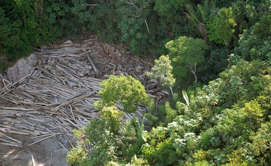
Environmentalists denounce "alarming" deforestation in Amazonas state

Amidst the month when Belém, the capital of Pará state, welcomed the Amazon Dialogues and Amazon Summit, pivotal gatherings uniting authorities and environmental advocates for discussions on sustainable regional growth, researchers are flagging the "alarming expansion" of clandestine forest pathways along BR-319 road in the southern part of Amazonas state.

A BR-319 Observatory (OBR-319) survey underscores the proliferation of such illegal routes, stretching across 5,092 kilometers in municipalities like Canutama, Humaitá, Manicoré, and Tapauá. This distance is nearly six times (5.8) the length of BR-319, which links the Amazonas and Rondônia state capitals, Manaus and Porto Velho, respectively. The period from 2016 to 2022 witnessed a 68 percent surge, adding 2,061 kilometers of new roads across the four municipalities analyzed.
"The rapid loss of vast forest areas within such a short timeframe is astounding. The surge in roads proliferation is shocking. Deforestation rates have accelerated drastically," affirms Thiago Marinho—a researcher at the Institute for Conservation and Sustainable Development of the Amazon (Idesam) and a key figure in the mapping project—during an interview with Agência Brasil. The speed of degradation is a concern.
"It is not only the large volume of roads but the very short time interval in which they appeared. This shows that there is a coordinated effort to dismantle forests, which is not being effectively stopped," Marinho laments.
Of utmost concern, most of these routes are located in so-called undesignated public forests (FPND). They comprise 2,803 kilometers or over half of the 5,092 kilometers. FPNDs lack a designated purpose, devoid of forest management schemes or protective coverage for indigenous communities. OBR-319 highlights their heightened vulnerability, susceptible to land usurpation, woodland decay, and deforestation.
Satellite images
The road network mapping was accomplished through the interpretation of satellite images generously provided by the NICFI Project (Norwegian International Climate and Forest Initiative), under the auspices of the Norwegian Ministry of Climate and Environment.
The selected four municipalities were under the observatory's lens due to their staggering deforestation figures. By juxtaposing ecological degradation data with satellite snapshots, the researchers were able to establish a connection between roads and deforestation. This evidence underscores that these informal roadways don't primarily serve local mobility or productive circulation but rather clandestine operations.
"Nearly all burning, deforestation, and logging, occur within 5 kilometers of a road. Thus, these activities are inextricably linked, emerging from these branching routes. The roads function as logistical arteries enabling these activities," explains Marinho.
Creating these pathways involves considerable investment, prompting researchers to suspect involvement from economically influential entities. "Forging over a hundred kilometers deep into dense, remote forests demands logistics, resources, and manpower. Such an endeavor is hardly characteristic of small-scale rural producers. The orchestrators of this operation wield significant financial resources," Marinho contends.
OBR-319, a coalition of civil society organizations, not only strives for sustainable development within BR-319's sphere but also denounces ecologically detrimental practices. Organizations like Greenpeace, WWF-Brazil, Sustainable Amazon Foundation (FAS), and Idesam collaborate within the observatory.


